GEOGRAPHICAL POSITION
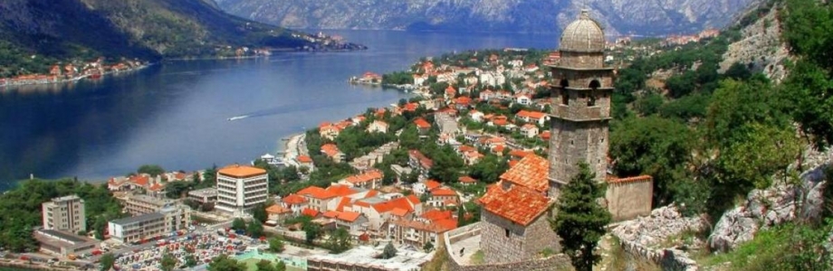
Boka Bay (mne. Boko-Kotorski zaliv) is the biggest gulf of Adriatic Sea and it’s listed as one of the 25 most beautiful bays in the world.
The Bay goes 28 km into the mainland. Total area of the Bay is 87.3 km2, length of coastline is 105.7 km, and the entrance is almost 3 km wide. Water salinity is 28%.
Bay is on the southeast side bordered with limestone massifs of Lovćen (1749m) and the north-west branches of Orjen (1895m), Radostak (1446m) and Dobroštica (1570m). Just above the town of Perast and between these mountains extends limestone massif Kason (873m).
On the northwest side of the entrance to the Bay is Vitaljinsko Peninsula and the South East another peninsula, Luštica. These two peninsulas are separated by the Strait of Sharp. Inside the bay there are two peninsulas Vrmačko and Devesinjsko, which separates the Strait of Verige. Straits Verige divides Boka Bay on the two outer bay, and Herceg-Novi (or Topljanski) and Tivat Bay, and two inner bays of Risan and Kotor.
So, Bay of Boka is formed out of 4 smaller bays – The Bay of Herceg Novi, situated between the capes of Arza and Oštra, as well as the isle of Mamula. From the Bay of Herceg Novi, through the Kumbor strait, we come into the Bay of Tivat. These bays made a basin of Boka Bay and are connected with other two bays – Kotor and Risan, with the narrowest but most beautiful strait of Verige.
Depth of the sea in the Bay is really impressive and varies from 20m (27.3 is the average) up to 60m (at its deepest point at Verige Strait), which allows giant cruiser ships to freely enter the Bay all the way to the city of Kotor.
Boka is decorated by seven different islands, namely: Mamula (Lastavica), Our Lady of the Rocks, Saint George, St. Marko, Charity, Flower Island and Little Lady.
Along the shore there is a chain of small towns and villages where every local fisherman could tell an interesting story about.
NATURAL VALUES
Area of the Bay of Boka, viewed as geomorphological and plant-geographical entity, is very rich in nature, that with special features makes an unusual contrast of relief, the remains of the tectonic disturbances, lime surfaces, as well as the deciduous vegetation in the coastal zone.
Given that stretches between the Adriatic Sea and Karst hinterland area of the Bay of Kotor is under the influence of Mediterranean and mountain climate, which, when are mixed to form a special kind of sub-Mediterranean climate, quite specific, unlike the rest of the coastline. With this type of climate, the average air temperature in January is 7 degrees, and in July around 23 degrees Celsius.
Thus, characteristic for Boka is the early spring, when all the surrounding mountains are covered with snow, on the coast of the Mediterranean blooming plants and trees. In winter it can also be enjoyed in the sunny days on the coast while in the mountainous region can be reached in less than an hour. Summers in this region are pleasant with more rainy days than the rest of the Montenegrin coast, which is reflected in the lush vegetation.
In the Bay has the most rainy days in late autumn and partly during the winter, especially in the inner part of the bay, where high mountains are blocking way of the clouds which come from the south and bring rain. Often, in wintertime, rain don’t stop for weeks, sometime even months.